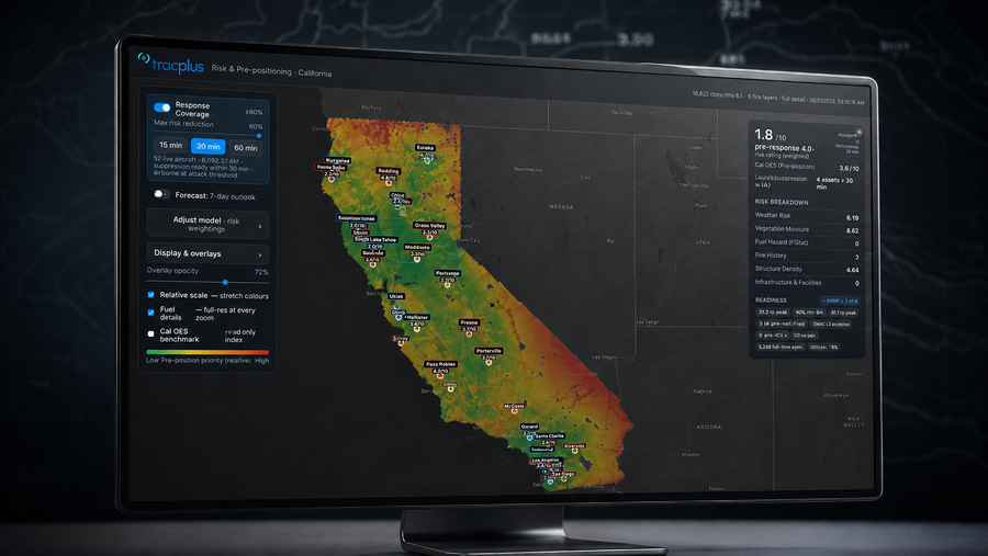
Auckland, New Zealand - 04 August 2026 - TracPlus, the operational data layer for aerial firefighting, has developed a research model that fuses many live and static data sources into a single picture of wildfire risk, and shows it alongside where the response fleet can reach. It is the first project from TracPlus Labs, the company's innovation function, and an early test of what the data available today can do to make decisions in the field easier.
Fire agencies already hold strong data on hazard, fire history, exposure, and weather. Each dataset answers one question, and they rarely sit together. The model brings them into one comparable picture, so the people making decisions work from a single view rather than a stack of separate ones.
The model divides a region into a fine grid and scores each cell for wildfire risk on a scale of zero to 10. It combines what is at stake in an area, its structures and infrastructure, with live and forecast conditions: weather, vegetation dryness, and fuel. The weightings are open and adjustable, and every score can be traced to the data behind it.
The approach builds on work TracPlus already does in aviation. For 15 years the company has fused aircraft telemetry and suppression data from sources like satellite, cellular, ADS-B, and onboard additional telemetry units into one operational feed at national scale. The risk model extends that same proprietary fusion algorithm to a broader set of environmental and operational data. TracPlus does this work with agencies and operators including CAL FIRE, the New South Wales Rural Fire Service, Australia's National Aerial Firefighting Centre, and Avincis in Europe.
The live position of the response fleet is also drawn into the model, to show where aircraft can reach in time, so risk sits alongside the ability to respond to it. High-risk ground that is well covered is distinguished from high-risk ground that no aircraft can reach quickly. The view is intended to support decisions made before a fire starts, such as where to position aircraft. The model informs those decisions. It does not make them, and it does not simulate a specific deployment.
Todd O'Hara, TracPlus CEO frames the problem as one of insight, not volume. "When we talk to customers, not one of them says they need more data," he said. "What they need is insight from the data they already have, and that is what we do. They are not short of information; they are short of a partner to help them make sense of it, wherever they operate. We have spent years taking messy data and adding enough context that it means something. This is that same idea pointed at risk: take various disparate data sources and turn it into one picture a person can act on."
In the first demonstration the model segments California into more than 10,000 cells, each about 14 square miles. That is roughly 180 times finer than a county-level index, so risk shows as a local picture rather than a single figure for a whole county.
For O'Hara, the work comes back to why TracPlus exists. "Aerial firefighting is difficult and dangerous, and the reason we obsess over this data is a simple one," he said. "It is to give the people in the aircraft and on the ground the clearest possible picture, so they can make the safer call before they are ever in a marginal position. Effectiveness is not about pushing harder; it is about better decisions made earlier. That is what makes the work more effective, more efficient, and safer."
The model is a research capability in development within FireFlyte, built on the TracPlus Mission Platform. The method is not specific to California; the first demonstration uses authoritative public datasets published by agencies such as CAL FIRE and FEMA and by national weather networks, together with TracPlus's own operational data. Further projects will follow from TracPlus Labs.
About TracPlus
TracPlus provides the operational data layer for aerial firefighting, and the operational data infrastructure that agencies and operators rely on at national scale. CAL FIRE, the New South Wales Rural Fire Service, and Australia's national aerial firefighting program are among its closest partners. TracPlus serves 700+ customers across 40+ countries, has recorded more than 6.5 million flight hours, and has been the only commercial provider of all-of-country aerial firefighting solutions in Australia and New Zealand since 2010. FireFlyte, created for aerial firefighting agencies, is built on the TracPlus Mission Platform.
Media contact:
Chris Macdonald | media@tracplus.com | +64 275 740 760
Notes to editors: TracPlus's paper on accountable AI in aerial firefighting, AI Makes the Call. Who Answers for It?, sets out the principles behind this design and is available at https://www.tracplus.com/tracplus-blog/when-ai-makes-the-call.