This blog will cover:
The Evolution of Aerial Firefighting Techniques
Early aerial firefighting strategies were primitive and limited. In the early 1900s, pilots would fly over fires and drop sand or water-filled bags on them to put them out. This method was not only ineffective but also dangerous for pilots.
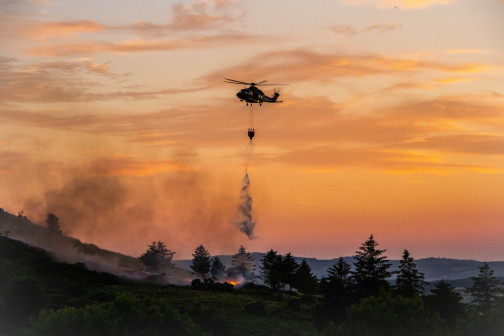
Over time, aerial firefighting techniques have evolved as technology has progressed. Today, aerial firefighting is carried out using helicopters and fixed-wing aircraft. Pilots drop water or fire retardant from the air, often in coordination with ground crews.
Early Aerial Firefighting Methods
Early aerial firefighting methods were rudimentary, but they helped pave the way for modern aerial firefighting techniques. The first use of aircraft in firefighting dates back to the 1920s, when biplanes were employed to drop water over fires. These planes had limited capacity and could only carry small amounts of water.
The 1940s marked a turning point in aerial firefighting. The P-47 Thunderbolt, a fighter plane used in World War II, was repurposed for firefighting. The aircraft could carry up to 1500 gallons of water or retardant, making it possible to fight fires on a larger scale.
The Introduction of GPS Technology in Firefighting
The introduction of GPS technology has brought revolutionary changes to aerial firefighting, making it safer, more efficient, and more effective. GPS devices help to track aerial firefighting efforts in real-time, providing valuable data that can help firefighters respond to fires more effectively.
GPS technology has also made it possible for firefighters to map out the perimeter of a fire and create a virtual boundary. This boundary helps firefighters to track the movement of the fire and predict its path. With this information, firefighters can deploy resources more effectively and make better decisions about where to focus their efforts.
In addition to GPS technology, aerial firefighting has also benefited from advances in fire retardant materials. Modern fire retardants are more effective and longer-lasting than those used in the past. They can also be dropped more accurately, thanks to the precision of modern aerial firefighting techniques.
Another recent development in aerial firefighting is the use of drones. Drones equipped with thermal imaging cameras can be used to identify hotspots and areas of the fire that are difficult to access. This information can help firefighters to target their efforts more effectively and make better decisions about where to deploy resources.
In conclusion, aerial firefighting techniques have come a long way since the early days of sand-filled bags. Advances in technology have made it possible for firefighters to respond to fires more effectively and safely. As technology continues to evolve, we can expect to see even more innovative solutions to the ongoing challenge of fighting wildfires. For example, the use of a common operating picture for complete wildfire response coordination.
How GPS Tracking Improves Aerial Firefighting Efficiency
Real-time Data for Better Decision Making
One of the main benefits of GPS tracking in aerial firefighting is the ability to provide real-time data with automated flight following. The GPS devices on aircraft can track their location, altitude, speed, and the amount of water or retardant released. This information can be used by incident commanders to make more informed decisions and adjust firefighting efforts in real-time.
Real-time data has become an essential tool in fighting wildfires. With the help of GPS tracking, firefighting teams can track the spread of fires, predict their behavior, and adjust their firefighting efforts accordingly.
For example, if the GPS data shows that the fire is spreading rapidly towards a residential area, the incident commander can quickly redirect firefighting resources to protect the homes. This can mean the difference between saving or losing homes and lives.
Additionally, GPS data can help incident commanders determine the effectiveness of different firefighting strategies. By analyzing the GPS data, they can see which areas have been covered by aircraft and how much water or retardant has been dropped. This information can help them make decisions about where to focus their efforts and allocate resources.
USFS AFF compliance regulations state the need for aerial firefighters to have reliable flight-following techniques in place in order to stay compliant and meet work contracts. GPS tracking technology allows for this USFS aerial fire compliance to be achieved.
Enhanced Coordination Between Ground and Air Crews
The introduction of GPS technology has also improved collaboration between ground and air crews. GPS-enabled communication systems allow for faster and more accurate communication between different firefighting teams. This allows for more effective coordination between ground and air operations, leading to better firefighting outcomes.
For example, ground crews can use GPS devices to track the location of aircraft and adjust their operations accordingly. They can also communicate with pilots in real-time, providing them with information about the location of the fire and any hazards on the ground.
GPS technology has also improved the safety of aerial firefighting operations. Pilots can use GPS devices to navigate through smoke and low visibility conditions, reducing the risk of accidents. They can also use GPS data to avoid flying into areas with high winds or turbulence, which can be dangerous for firefighting aircraft.
Improved Accuracy in Water and Retardant Drops
GPS tracking has also improved the accuracy of water and retardant drops. Pilots can now target specific areas of the fire more accurately, reducing waste and maximizing the effectiveness of firefighting efforts. GPS technology also allows pilots to adjust their flight paths and drop patterns based on real-time data, reducing the risk of flight path conflicts between multiple aircraft.
For example, if the GPS data shows that the fire is spreading rapidly in a particular direction, pilots can adjust their flight path to target that area more effectively. They can also adjust the amount of water or retardant dropped based on the size and intensity of the fire.
Overall, GPS tracking has revolutionized aerial firefighting operations. Real-time data, enhanced coordination, and improved accuracy have all contributed to more effective and efficient firefighting efforts. As wildfires continue to pose a significant threat to communities and ecosystems, GPS technology will play an increasingly important role in protecting lives and property.
GPS Tracking for Firefighter Safety
Monitoring Firefighter Locations in Real-time
GPS tracking has also improved firefighter safety. GPS devices on firefighters' equipment and vehicles can monitor their locations in real-time, allowing incident commanders to track their movements and ensure their safety. This can be particularly useful in areas where firefighters are working in remote locations or in areas with low visibility.
Identifying and Avoiding Dangerous Situations
GPS technology also helps to identify and avoid dangerous situations. GPS devices can track the location of the fire and the positions of firefighting crews, allowing incident commanders to identify hazardous areas and alert firefighters to potential risks.
Facilitating Faster Rescue Operations
GPS tracking can also facilitate faster rescue operations in the event of a firefighter injury or emergency. Incident commanders can use GPS data to pinpoint the location of the injured firefighter and send rescue crews to their aid more quickly.
Case Studies: GPS Tracking in Action
The Role of GPS in the California Wildfires
The California wildfires of 2018 were some of the most devastating in the state's history. GPS tracking played a critical role in the firefighting efforts. GPS devices on aircraft and firefighters were used to track the locations of the fires, monitor the spread, and coordinate firefighting efforts. The use of GPS data helped to contain the fires and prevent further damage.
GPS Tracking in Australia's Bushfire Response
The 2019-2020 bushfire season in Australia was one of the worst in the country's history. GPS tracking played a crucial role in the firefighting efforts. GPS devices on aircraft and firefighters were used to track the spread of the fires and coordinate the response efforts. Aerial firefighting tracking with GPS technology allowed firefighters to respond more efficiently and effectively, leading to better fire containment.
Combating Forest Fires in Europe with GPS Technology
In Europe, GPS technology has been used to combat forest fires. A consortium of European agencies developed a system to track wildfire risk and the effectiveness of firefighting efforts using GPS technology. The system monitors hotspot locations, evaluates burn severity, and tracks the movement of fire perimeters in real-time. The use of GPS technology has allowed firefighters to respond more effectively and prevent the spread of forest fires.
Conclusion
The use of GPS technology has revolutionized aerial firefighting, making it safer, more efficient, and more effective. Real-time data and enhanced coordination between ground and air crews have led to better firefighting outcomes. The use of GPS devices for firefighter safety has also improved response times in emergency situations. GPS tracking has become an essential tool in fighting wildfires, helping to protect lives and properties around the world.
If you want to ensure you're remaining as safe as possible in your aerial firefighting operations, reach out to us today.